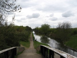
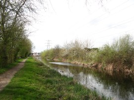
(1) The start of the Slough Arm
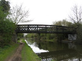
(2) Footbridge over the canal
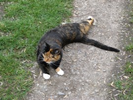
(3) A very friendly cat
Other Links >>> |
|
GRAND UNION CANAL - Part 3
The Slough Arm
I did this walk on Sunday 3rd April 2011, continuing on after having walked up from Brentford to Cowley Peachey Junction which marks the junction between the Slough Arm and the main Grand Union Canal. Construction of the Slough Arm began at the Cowley Peachey junction in early 1880, overseen by Alfred Walker. The route included a major cutting and embankment at Iver and the five mile stretch of canal opened on 4 December 1882.
|
|
|
|
(1) The start of the Slough Arm |
(2) Footbridge over the canal |
(3) A very friendly cat |
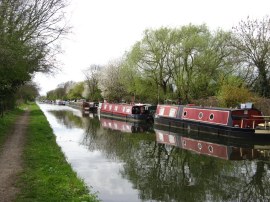
Crossing over Cowley Peachey bridge I began heading down the canal, photo 1, towards Slough, the towpath soon passing the entrance to the Packet Boat Marina on the right. For a short while the route is shared with that of the London Loop, which leaves the canal across the bridge in photo 2, and also a little further on by the route of the Beeches Way which follows the towpath for just over a third of a mile from this point. I walked the Beeches Way a couple of years ago now but have just realised I never wrote up the walk. As I was walking along this part of the path a friendly cat appeared from the undergrowth and began rolling around by my feet, photo 3; hopefully it wasn't lost or abandoned and just being sociable. I do tend to have a certain attraction for cats, there are a couple of elderly ladies who live in my street who call me the Pied Piper of Cats, and I now have four strays living in the house and two more that I feed.
 |
 |
 |
(4) Colne Brook Aqueduct |
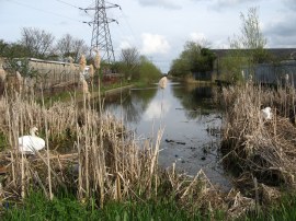
(5) Moorings besides the Canal nr Iver |
(6) Fishermen on the canal |
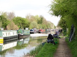
Photo 4 is of a small aqueduct over the Colne Brook, one of three such aqueducts that are encountered in quick succession on this stretch of the towpath. The sound of traffic on the M25 grew increasingly loud as I made my way along the canal bank and once under the M25, the route continues ahead along a fairly section of canal with light industrial units above the embankment on the right. The views to the left of the canal were completely obscured by the embankment alongside the canal as the path heads through the cutting by Iver. Just over two miles from the junction the route passed a large area of residential moorings for canal boats, lined up two deep along the edge of the canal, photo 5. The seemingly tranquil nature of the setting though was frequently disturbed by the sound of trains on the main line rail link into Paddington that runs just a few hundred yards to the left of the canal. About halfway along this area of moorings a fishing competition was taking place, the canal lined by a large number of evenly spaced anglers all fishing using long black poles, photo 6.
 |
 |
 |
(7) Another abandoned office |
(8) 1 mile from the end of the canal |
(9) Heading towards the end of the canal |
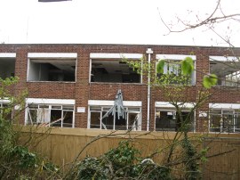
After bridge 8 over the canal the path heads alongside the edge of the tall brick factory wall alongside the edge of the canal before passing under bridge 9 and heading out into a slightly greener area although there was still was a lot of industrial activity taking place not far from the canal side. Some of these factory units were abandoned and in the process being demolished, photo 7. A mile or so from the end of the canal the route reaches the outskirts of Slough, running alongside houses and the occasional patch of parkland, photo 8. Reaching the Uxbridge Road bridge there was an information board describing the history of the canal, which also stated it takes three hours to walk the five miles to Cowley Peachey junction which seems somewhat excessive, even for a casual walker. Just after I had finished reading this sign I saw a rat run close past my feet and jump into the canal before swimming rapidly across to the other bank. Unfortunately my camera took too long to start up that by the time I was able to take a photo the rat had disappeared on the other side of the canal leaving only a miniature set of bow waves marking its path across the water. From the bridge there was one last straight section of canal, photo 9, down to its terminus.
 |
 |
(10) The end of the Slough Arm |
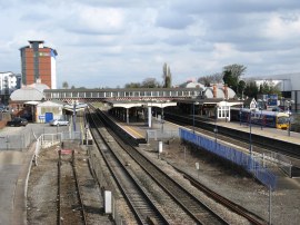
(11) Slough Station |
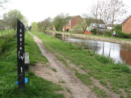
The Slough Arm ends somewhat unceremoniously when it reaches the B416 Stoke Road, the end of the canal surrounded by a builders merchants and a dusty parking area. There were a couple of rather litter strewn areas of reeds at the end of the canal although had not deterred a couple of swans from nesting there. From the end of the canal I headed to the left along the road where it was about a half mile walk to reach Slough Station, photo 11 where I caught the train home.
As usual I have uploaded the route of the walk which can be accessed here: Slough Arm.
Again there was not too much memorable or scenic on this short section of path up to Slough. My transport problems also continued on the way back, I arrived at the station 10 minutes before a train was due but this ended up being delayed by half an hour and when it did arrive it was standing room only for the journey back to Paddington, hopefully future transfers will go a bit more smoothly. The Slough Arm was exactly five miles long and I had walked a total distance of 16.4 miles for the day.
If you would like to comment on this walk you can do so here:
![]() Back to:Walk index page
Back to:Walk index page
| ©2012 Bertuchi.co.uk. Please contact me using the email button on the right if you have any questions or comments regarding the site. Any feedback and additional information about places of interest on the walks is always welcomed. All rights reserved. Please contact me if you want to use any of the images or information from the site. ENJOY YOUR WALKING |
|