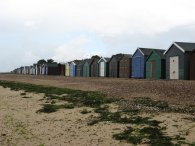
(1) Beach huts, West Mersea
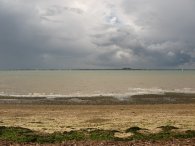
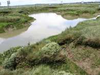
(2) Blackwater Estuary
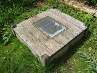
(3) St Peters Well, West Mersea
MERSEA ISLAND
I did this walk on Saturday 15 June 2007. After having spent most of the year to date walking around Hertfordshire I thought it was time that I do something different and thus headed off to Essex to walk round Mersea Island.
|
|
|
|
(1) Beach huts, West Mersea |
(2) Blackwater Estuary |
(3) St Peters Well, West Mersea |
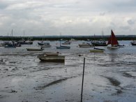
It had been raining in the morning when I left home and the rain seemed to follow me along the road all the way to Mersea and on reaching the island I was caught in a torrential downpour just as I drove over the causeway. This reduced visibility to almost nothing and the traffic was forced to slow almost to a standstill for a few minutes which made a rather dramatic introduction to the place. Driving through West Mersea I found a free car park by the life boat station but this was full so I made my way back through the town and parked at the Esplanade Car park which cost £2.00 for the day. As I was arriving at the car park there was a flash of lightning and big rumbles of thunder were echoing across the sea. I sat in the car for a few minutes, waiting for the worst of the weather to clear which it duly did and then set off along the beach, walking in a clock wise direction past the beach huts, photo 1, which were lining the edge of the car park. Although it had stopped raining there were still dark clouds all around. Photo 2 was taken looking across the Blackwater Estuary towards Bradwell, the little bump on the horizon in the photo being the Bradwell nuclear power station. At the end of some beach front houses I headed slightly right and then left along the grassy footpath that runs parallel with the road past St Peter's Well, photo 3, at the top of the beach.
 |
 |
 |
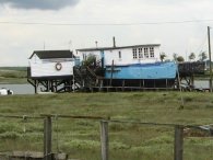
(4) House boat, West Mersea |
(5) Sailing boats nr Mersea Fleet |
(6) The Strood Channel |
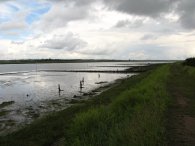
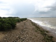
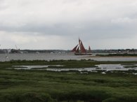
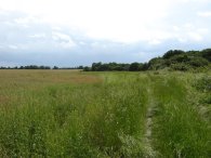
Walking along this stretch path I saw a white little egret but it flew off before I had time to take a decent photo, settling once again just out of range. A little further on the footpath leads up to a road where my route headed past the West Mersea Oyster Bar and Seafood Restaurant. Passing the coast road car park near the lifeboat station I was annoyed to see that there were now two free car parking spaces as this would have been a much nicer place to park than where I ended up. The route goes past the Dabchicks sailing club then turns slightly left to rejoin the sea wall along the side of the creek. All around were boats, both houseboats drawn up on the marshes, photo 4, and sailing boats out on the creek, photo 5. On the way I also passed a number of stores selling fresh fish, prawns and other seafood and there were also a number of tempting cafes. Continuing along the sea wall the route passes a caravan site on the right and then heads along the sea wall with fields and marshes on the right and the Strood Channel to the left, photo 6. As I walked the air was filled with scent of salt and sea weed, very different from the Hertfordshire countryside!
 |
 |
 |
(7) Causeway to the mainland |
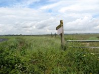
(8) Footpath sign |
(9) Sea wall breach |
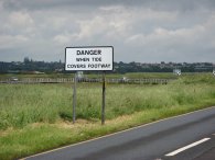
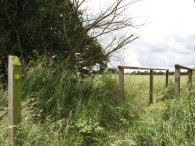
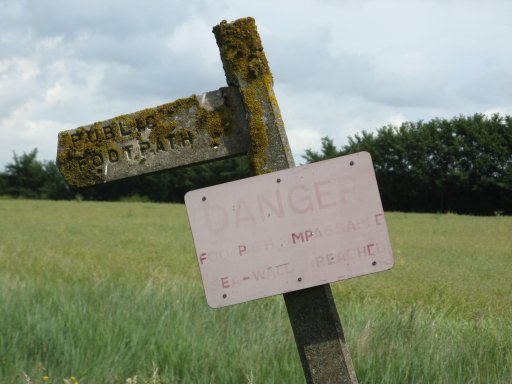
Reaching a road the route turns left and heads down towards the causeway that leads over to the mainland where a sign read "Danger when tide covers footway", photo 7. Just before the causeway is reached I turned right up the road that runs towards East Mersea. This is followed a couple of hundred yards until an entrance to a farm gate is reached that leads to a footpath which runs back down parallel with the road I had just walked down to reach the creek once again, photo 8. This footpath was very overgrown and hardly seemed to have been used which made it hard going making the way along the top of the flood bank in the high grass. After about 10 minutes walking, although I had not gone very far, the reason why the footpath was so overgrown and underused became apparent as the sea wall had been breached and there was no way to continue across the muddy creek. I could have jumped over the two little gaps where I stopped, photo 9, however it looked like further on there was a bigger breach. Thus I had to retrace my steps back along the sea wall to the road.
 |
 |
 |
(11) Footpath from East Mersea Road |
(12) Footpath from East Mersea Road |
Despite having stopped and taken photo 8 when I had reached the footpath I saw that I had somehow missed the rather faded sign, photo 10, attached to the footpath marker that had once stated "Danger footpath impassable sea wall breached" although this was now all but invisible on the sign. If only I had noticed this the first time around! Perhaps a better notice should be erected.
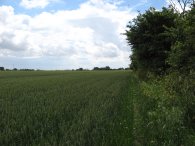
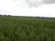
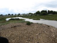
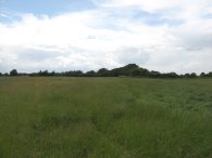
Anyway the closure of the footpath had completely thrown out my plans of walking around the island as there was no near alternative to get back to the sea wall whatsoever so I had to have a major rethink of what I was going to do. I was also hampered by not having a proper map of the island. I always carry a map with me but I thought that walking round the sea wall did not really require me to purchase the map in this instance. However after some deliberation I decided on a general walk over the island, rather than around the island. Leaving the sea wall path I headed up the road towards East Mersea and then turned right along Dawes Lane. Having just past Smiths Hall on the right I turned left along a footpath than ran across a field. Reaching a hedge the route turns right and at the end of the hedge left again across another field of wheat. This lead back round to the East Mersea Road, which I had been on earlier, where again I turned right passing across the top of Jackmans Lane. Heading along the road past a few houses I took a footpath that runs down the right hand side of the second field on the right, photo 11. The path down beside the field was quite overgrown and wet from the earlier rain which made walking quite difficult. About three quarters the way down the field the footpath crossed a small bridge, photo 12, to the right to run down the other side of the hedge. On this side the path was so overgrown that it was impossible to walk through so I came back and continued along the other side of the hedge. Reaching a hedge at the end of the field the route turned left and was rejoined by the proper route of the footpath.
 |
 |
 |
(13) New buildings, York Way |
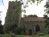
(14) East Mersea Church |
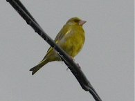
(15) Greenfinch, East Mersea Island |
Crossing the bottom of the second field the route crosses a bridge and joins a farm track which is followed straight ahead to a road. The route crosses straight across the road heading to the right of a converted barn house to take a broad farm track that heads along over the fields, photo 13, to East Mersea Church, photo 14. To the right the creek is just a couple of fields away. Whilst I was walking along this stretch I got caught in a very heavy downpour although I was able to get some reasonable shelter from a hedge as the rain blew across the fairly open ground. Reaching the road by East Mersea Parish Church I then turned right and headed into the entrance Coopers Beach Holiday Park which is along a public right of way. The footpath continues along the surface track that leads round the side of the caravan park to reach the sea wall where I turned left to continue round the island. On the way I spotted a Greenfinch, photo 15, perched on the telephone wires above the path. I am really pleased with this photo given the bird was so far above me.
 |
 |
 |
(16) Coopers Beach Holiday Park |
(17) View over the Blackwater Estuary |
(18) Sea Shore, Mersea Island |
I walked along the low sea wall besides the caravan site, photo 16, the caravans looking rather dreary in the wet weather. To my left were expansive views out over the estuary, photo 17. Leaving the caravan site the path then runs along the shore edge on a narrow band of shingle separating the sea from some marsh land on the left. It was almost high tide and there was only a narrow patch of shingle actually available to walk on, photo 18, the Mersea flats being hidden underwater.
 |
 |
 |
(19) Rain showers, Mersea Island |
(20) Stream, East Mersea |
(21) Stream, East Mersea |
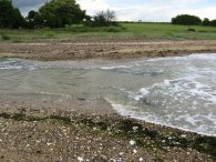
Once again there was another torrential burst of rain but fortunately they were only lasting 5 or 10 minutes at a time and once again I was able to find some shelter in the greenery beside the beach. Out at sea more showers could be seen passing over, photo 19. A little way ahead I once again found my way obstructed, this time because of a stream that was in full flow, photo 20. Normally I think you would be able to step over this but because of the high tide and the rain it was fairly impassable. To get back to the coast on the other side of the beach appeared to involve a considerable detour, photo 21, so in the end I took my shoes and trousers off and waded across. Although only a short stretch, the water was well over my knees.
 |
 |
 |
(22) Coastal erosion, Mersea Island |
(23) Sea Wall, Mersea Island |
(24) Brightlingsea Reach |
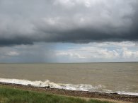
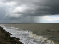
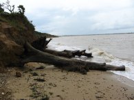
Having dried off, the small towel I always carry in my rucksack being put to good use, I continued along the beach past an area of low crumbling earth cliffs dodging the gentle waves which were reaching up to the cliff edge in places. Fallen trees on the beach, photo 22, highlighted the erosion taking place at this point. Leaving the beach I took a slip way up into the Colne Estuary Nature reserve and the Cudmore Grove Country Park. Here the path ran along a tarmac surfaced sea wall, photo 23, which gave a few minutes easy walking down towards Brightlingsea Reach, photo 24, were a small foot ferry occasionally links East Mersea with Brightlingsea and St. Osyth Stone at Point Clear. The route then follows the sea wall and creek around to the left. Ahead of me a massive thunder storm was raging but fortunately this passed me by which was fortunate as is was quite an exposed place to be in a thunder storm and options for shelter were pretty non existent.
 |
 |
 |
(25) Sea wall besides Brightlingsea Reach |
(26) Leaving the sea wall |
(27) Fields, Mersea Island |
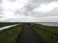
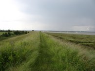
The path continues along the broad grassy track, photo 25, on top of the flood bank which fortunately on this occasion was not too overgrown to make a quite pleasant walk along side the Brightlingsea Reach and round to the Pyefleet Channel. As I was walking along the path a flock of seagulls were flying slowly overhead, gently mirroring my progress along the path which is not behaviour I had come across before. After about a mile or so the path leaves the flood bank and heads down through a metal kissing gate to cross a field heading towards a small patch of trees, photo 26. Reaching a fence at the far side of the field the footpath turns left along the field edge to enter into the trees. Running just inside the woodland the path goes up some steps up over the top of what appeared to be the remains of a large air raid shelter, which had a little glass skylight on the top, before descending down more steps on the other side. The route continues on to join a gravel path along side some houses continuing besides the trees. Joining a road the route turns right and then about 50 yards further on the road bends to the left continue straight ahead through a kissing gate into a field, photo 27. The footpath makes its ways over a couple of fields into a larger field where there is farm track along down the side. This leads to a driveway where the route heads right then almost immediately left to join another footpath running along the edge of a field. This path was once again quite overgrown and difficult to walk on. Reaching a gap in the field in the hedge I turned left and followed the left hand side of the hedge round as it makes it way down towards Weir Farm. Level with the farm I turned right over the field to pass the farm buildings and then left past the end of the buildings to reach the road , Here I turned briefly left along the road and then right into Rewsalls Lane.
 |
 |
 |
(28) Mersea Island Vineyard |
(29) Beach, nr West Mersea |
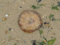
(30) Beached Jellyfish |
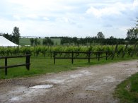
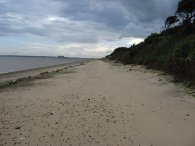
Heading down the lane I passed Rewsalls barn which I passed when I had crossed Rewsalls Lane on route to the East Mersea church earlier on in the day. This time I continued down the road past Mersea Island Vineyard, photo 28, and on to the Mersea Outdoors Centre for Outdoor Learning, which the path then heads through to reach the coast path once again. At the end of the outdoor centre I turned left down the slip way and started walk along down the beach to the right which at this point was fairly decent sand, photo 29. As I walked back along the beach towards the car there was a strong wind blowing in my face and on the beach a number of jelly fish had been washed up on with the high tide.
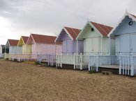 |
(31) Beach huts, West Mersea |
Not long before reaching the car park I passed some newly painted beach huts, photo 31. Reaching the car I had walked a total distance of 14.8 miles, having ended up doing a figure of eight walk around the island.
Despite the weather this had been a very enjoyable walk through the sort of landscape that I seldom seem to visit. Several months later this still rates as one of the best walks of the year so far and I will definitely being doing more walks in the area.
I have marked the route of the walk on a Google map, the link to which can be found here: Google map
![]() Back to:Walking index page
Back to:Walking index page
| ©2008 Bertuchi.co.uk. Please contact me if you have any questions or comments regarding the site. Additional information about places of interest on the walks is always welcomed. All rights reserved. Please contact me if you want to use any of the images or information from the site. Thank you. |
|