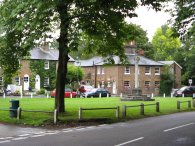
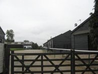
(1) Letchmore Heath
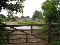
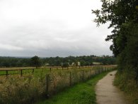
(2) Path nr The Fruit Farm
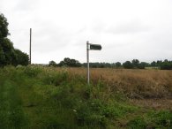
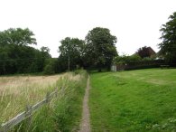
(3) Path nr Little Kendals Farm
Other Links >>> |
|
THE HERTFORDSHIRE WAY - DAY 17
Letchmore Heath to South Mimms
I did this walk on Wednesday 11th July. I had a rather slow journey up to Letchmore Heath from Walthamstow where I was able to park almost exactly where I had finished my last walk along the Hertfordshire Way, some two and half weeks ago. When I had last been in Letchmore Heath it was raining and once gain the weather was grey and wet as I set off. It had been raining heavily earlier which had left the grass in the fields very wet which soaked my legs as I walked through although fortunately the day got steadily brighter with no more rain.
|
|
|
|
(1) Letchmore Heath |
(2) Path nr The Fruit Farm |
(3) Path nr Little Kendals Farm |
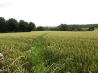
The route turns left by the Three Horseshoes pub in Letchmore Heath, photo 1, and follows Back Lane up to bear right onto Common Lane. A little further along the route heads up the gravel driveway on the right of a house called "The Cottage". Passing the house the route continues ahead along a grassy track before crossing through a wooden gate and over a tarmac driveway that leads to "The Fruit Farm", photo 2. From here the route continue along another gravel track and past another house to enter a field. The route then follows field edges until it reaches a footpath sign which points to the right to head across the field, photo 3. As on several occasions in this area there was no Hertfordshire Way Markers marking the route and I was glad I had my copy of the Hertfordshire Way guidebook with me to help ensure I kept on track.
 |
 |
 |
(4) Trees by Little Kendals Farm |
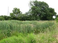
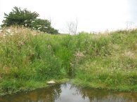
(5) Pond nr the A5183 |
(6) Bridge, Tykes Water |
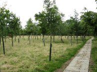
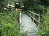
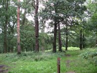
Having crossed the field, the path turns left past a rather muddy pond on the right before heading over a stile and gate combination into an enclosure of young trees with a rather nice stone path running round the side, photo 4. Leaving the trees the route heads down over a grassy field which has a nice reed lined pond tucked away in it, photo 5, before reaching the A5183 Watling Street where the route turns to the right for a short distance before taking a road off to the left signposted Kendal Hall Farm. Just past the entrance to the Hertsmere Jewish Primary School, complete with security guard on the gate, the route crosses a stile into a field, running parallel with a line of large electricity pylons. There was only a very vague path through the knee high grass in the field as headed towards the bottom left hand corner of the field where the route joined a broader grassy track that runs off to the left parallel to some railway lines, just hidden behind the trees to the right. The route crosses under the railway lines through an arched bridge and heads on to cross over Tykes Water on a newly built wooden bridge, photo 6, before forking slightly to the right to take a footpath that runs up the left hand edge of a field to reach a road, Theobald Street.
 |
 |
 |
(7) Path nr Theobald Road |
(8) Heading towards Wood Hall Farm |
(9) Wood Hall Farm |
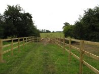
Crossing the road the Hertfordshire Way heads straight ahead along a track that leads to a field that has recently had a fenced path laid across it, photo 7. The route then heads into another more open field and makes its way gently uphill. The path exits this field at the top left hand corner crossing a wooden bridge before heading along a grassy tree and hedge lined track, photo 8. This path makes it way steadily uphill before joining a farm track and heading off to the right passing through the farm buildings of the Wood Hall Estate, photo 9. Leaving the buildings, the Hertfordshire Way turns right along Woodhall Lane.
 |
 |
 |
(10) Path to Radlett Lane |
(11) Path to Cow Bank Wood |
(12) Cow Bank Wood |
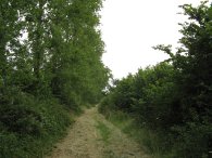
Just past an old pillbox on the left the Hertfordshire Way heads to the left through a thin patch of woodland along a path signposted Radlett Lane ½ mile. This soon leaves the trees and heads alongside a field, photo 10. Reaching Radlett Lane the Hertfordshire Way heads straight across the road and takes a stile and turns left into the grounds of Shenley Park. The Hertfordshire Way continues ahead through the car park, where there are toilets and a tea hut, and follows the road round to the right at the end and then turns right past the Stable Flats. Once past the flats the path heads up to a road before taking a path off to the left signposted Cow Bank Wood 1.1 kilometers. This broad path curves round the back of houses with fields to the left, photo 11. The path makes it way through Cow Bank Woods, photo 12, on a clearly defined path that generally sticks close to the edge of the woodland before taking a broad path to the right that runs between gardens down to Porters Park Drive where the Hertfordshire Way turns left. This path wasn't signposted as the Hertfordshire Way and I walked past the turning at first. While I was heading in the wrong direction I spotted a dead gerbil at the side of the path in the wood which was a rather unusual sight, I presume it must have escaped from one of the nearby houses.
 |
 |
 |
(13) Fields nr Shenley |
(14) Ramblers! |
(15) Plaque |
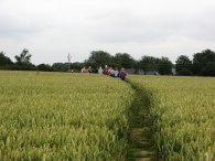
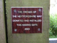
From Porters Park Drive the route turns left down the B5378 Shenleybury Road. Just past the Good Shepherd church the route crosses the road and takes a footpath that runs down besides a field edge gradually pulling away from the road. Just before the path the reaches the graveyard of London Colney church the Hertfordshire Way takes a footpath that runs diagonally over the field to the right, photo 13. Although there was a path through the crop I managed to miss this the first time I walked past and continued on into the churchyard in error. Crossing the field the path goes through a small patch of low scrubby woodland before entering another larger field. Crossing this I encountered a group of 30 ramblers heading in the other direction, all who seemed to be at least in their 60's or 70's, photo 14. I hope I am still fit enough to be out and about when I am their age! The path then crosses a farm track and heads once again across another larger open field by the corner of Dell Grove. Joining a farm track, the route makes its way gently uphill between paddocks. Reaching a road by Rectory Farm the Hertfordshire Way turns to the left down Rectory Lane. Reaching an house on the left the route takes a footpath off to the right signposted to Rabley. The path heads over a couple of small fields, crosses a driveway and continues ahead into another scrubby field. The path crosses a road by Rabley Park farm and continues ahead over another small field, heading downhill to a small stone monument. Passing the monument the Hertfordshire Way passes through a kissing gate with a little plaque stating it was donated and erected by the Friends of the Hertfordshire Way, photo 15, before heading downhill to reach the overgrown banks of Catharine Bourne.
 |
 |
 |
(16) Bull |
(17) Catharine Bourne |
(18) Approaching the M25, nr South Mimms |
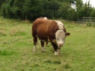
Here the route turns left following the edge of the water course over the fields, one of which was guarded by a bull, photo 16. Parts of this section of path approaching the M25 where quite overgrown and were clearly not that well used although with all the rain recently and generally mild temperatures it has been ideal conditions for the rapid growth of the greenery. At a ford, photo 17, it was possible to get a brief glimpse of the water in the Catharine Bourne before passing under the M25, photo 18. Once under the motorway the route runs besides another field, currently planted with broad beans, before heading across the B556 into another field, now following the other bank of Catharine Bourne. The route then takes a footbridge back over the Bourne and takes a fenced path between gardens and houses to reach Black Horse Road in South Mimms, close to the Black Horse Pub where the Hertfordshire Way turns to the right for a short distance.
This is where I finished my walk along the Hertfordshire Way for the day, having walked 8.1 miles
 |
 |
 |
(19) St Margarets Church at Ridge |
(20) Heading towards Shenley |
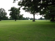
(21) Playing Fields, Aldenham School |
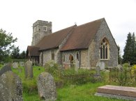
From here I continued up Black Horse Road, along Blanche Lane, past South Mimms Church and over the M25 before turning briefly right into Earls Lane and then taking a footpath a few yards down on the left. This footpath crosses fields and leads onto a road by St Margarets Church at Ridge, photo 19, before continuing through the churchyard and over more fields for about 11/2 miles to reach the outskirts of Shenley. The route up over field to Pursley Farm where I turned right onto the main road. I then turned left down Wood Hall Lane where I linked up with my outward route along the Hertfordshire Way which I followed all the way back to Watling Street. Here I headed straight across the road and took a foot path that makes its way along field edges towards the village of Letchworth Heath passing the playing fields of Aldenham school on the way, photo 21, before turning right along a road to reach Letchmore Heath and th end of the walk.
When I reached the car I walked a total of 14.2 miles. I now only have one more stage to walk to get back to Cuffley where I started my walk around the Hertfordshire Way. One feature of this walk was the overgrown state of a number of the paths and also the intermittent signage. Without the guidebook I would have gone astray on a number of occasions as the route is not marked on my rather old copies of the Ordnance Survey Explorer maps 173 and 182 which this part of the path crosses through.
![]() Back to:Walk index page
Back to:Walk index page
| ©2012 Bertuchi.co.uk. Please contact me using the email button on the right if you have any questions or comments regarding the site. Any feedback and additional information about places of interest on the walks is always welcomed. All rights reserved. Please contact me if you want to use any of the images or information from the site. ENJOY YOUR WALKING |
|