(1) Greensand Ridge, Nr Linton
(2) Greensand Way, Hunton Hill
(3) Greensand Way, Nr Barn Hill
Other Links >>> |
|
GREENSAND WAY - Part 3
Linton to One Tree Hill (Nr Sevenoaks)
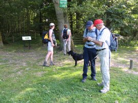
I did this walk on Sunday 4th July 2010. In marked contrast to the previous stage it was a very warm, bright sunny day although for much of the day there was a strong wind blowing towards us which helped keep the worst of the heat away. Six of us had met up at One Tree Hill before driving over to resume our walk from Linton Church.
|
|
|
|
(1) Greensand Ridge, Nr Linton |
(2) Greensand Way, Hunton Hill |
(3) Greensand Way, Nr Barn Hill |
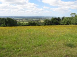
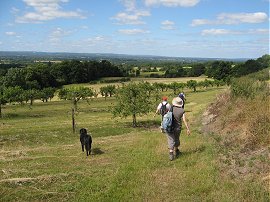
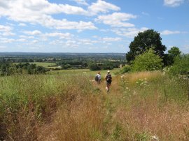
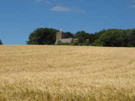
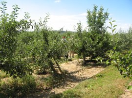
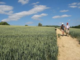
From the car park the Greensand Way heads up to the A229 Linton Hill, heading uphill along the road for a few yards before joining a footpath on the left. This soon heads out into fields and orchards, running just below the top of the Greensand Ridge with good views to our left over the Weald of Kent, photo 1. Reaching Vanity Lane the route heads straight across, continuing ahead on a fairly straight course alongside more fields and orchards to Westerhill Road. Once again the route heads across the road, briefly joining a lane by some houses at Reason Hill before bending round to the left then soon turning right to continuing ahead alongside orchards, with an area of trees to the right, to reach Hunton Hill. Here the Greensand Way heads up the road to the right for a few yards before joining another footpath on the left, heading alongside the newly planted orchard in photo 2 which is typical of the scenery we had been passing through so far. Reaching a converted oast house the path heads slightly to the left to join a driveway which leads to the road at Barn Hill. Once again the route heads uphill to the right for a short distance before joining a footpath on the left. This runs along a field edge for a short distance before bending round to the left, as the route starts heading downhill along the field edge, photo 3.
 |
 |
 |
(4) Greensand Way, nr Buston Manor |
(5) Yalding |
(6) Town Bridge, Yalding |
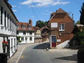
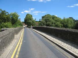
At the end of the tall tree lined hedge the route continues heading downhill across the middle of the field. When we went by it had been planted with rape and the fast ripening crop was covering much of the path leaving us to push our way through the greenery. Reaching a fence the route turns to the left, passing alongside the oddly named Malice Wood to join a track that runs between the buildings of the farm complex at Buston Manor where photo 4 was taken looking back uphill just before the farm buildings were reached. Leaving the farm, the route heads along the bottom edge of a field before turning to the left down a byway which is followed downhill to Lughorse Lane. Here the route heads to the right for a short distance before joining a footpath on the left. Heading down the edge of a short field the route then turns to the right to join a track that runs into the outskirts of the village of Yalding. Here the route joins a footpath that runs between the houses from Mount Avenue to join Vicarage Road, close to its junction with Yalding High Street. We then followed the High Street through the village, photo 5, where some of the group stopped for a quick slice of cake from a little cafe. The cakes did look quite nice but I decided to wait for my pack lunch! Heading along the High Street the route crosses the River Beult over the Town Bridge, photo 6. The bridge, which built of ragstone, is the longest medieval bridge in Kent.
 |
 |
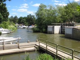 |
(7) Yalding Sluice |
(8) Hampstead Rd Canal, Yalding |
(9) Hampstead Lock, Yalding |
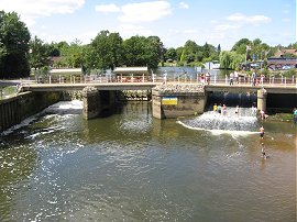
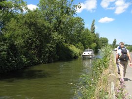
Once over the bridge we headed to our right along the Lees Road before joining a footpath on the right which headed over a patch of open ground known as The Lees. We had a little break under a tree which was surrounded by a bench before heading on to the Hampstead Lane where we headed to the right to cross the Twyford Bridge which runs over the River Medway. Just upstream from the bridge is the Yalding Sluice and a number of people where playing in the water which was running of the overflow channel, photo 7. The water looked very murky and was not somewhere I would want to go paddling however warm the weather. The Greensand Way heads on past the Anchor Inn, where Maria left us for the day as it made a convenient stop for her to get the train back home while we continued ahead, following the road alongside the Hampstead Road Canal, photo 8, which carries the river Medway round the Yalding Sluice. Reaching Hampstead Lock, photo 9, the route heads down to run alongside the river for a short distance before joining a path on the left that heads over the railway lines just below Yalding Station. Looking back over the Medway we were able to see a number of fields of lavender growing on the tops of the hills on the other side of the valley, the dark blue flowers adding a vivid splash of colour to the landscape.
 |
 |
 |
(10) Heading towards Moat Wood |
(11) Moat Wood |
(12) Carved Way Marker |
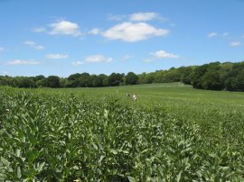
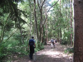
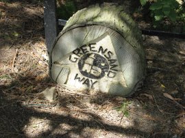
Once over the railway the route heads diagonally across a field before turning to the left to run alongside a wire fence separating two more fields up to the road at Nettlestead. One of these fields was in the process of being cut and the smell from the fairly green hay made my nose run for quite some time. The Greensand Way heads straight across the road and down the side of house where a pleasant man, who told us he had just brought the house, was doing some gardening; I wondered whether he had realised he had footpath running right past his front door. The path heads uphill to a field and heads through a gap between two areas of trees to head diagonally uphill across a large field, photo 10, in which Dave and Derek can just about be seen in the distance heading between the crop of Broad Beans. At the end of the field the route passes through Moat Wood, photo 11, before heading over some grass covered fields to join a track that heads towards a house. Just before the house is reached the route leaves the track, which we didn't do at first, and heads to the right into a small area of trees which leads down to the Roydon Hall Road. Here we turned to the right along the road for a while before joining a footpath on the left, this heads over a field and through a small area of trees where the route was marked by the carved wooden way marker in photo 12.
 |
 |
 |
(13) Approaching St Michael's Church, East Peckham |
(14) St Michael's Church, East Peckham |
(15) Group Photo, West Peckham |
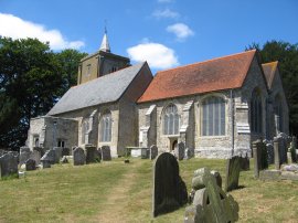
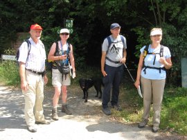
Leaving the trees the path joins a larger field, photo 13, first running along the right hand field edge, then heading across the field to reach St Michael's Church in East Peckham, photo 14, where we stopped for our lunch break, sitting on a wall under the shade of the trees surrounding the churchyard. Leaving the church the route heads to the left along Old Church Road to the A228, heading straight across to join a path that leads down to cross the A26, Maidstone Road. Here we turned to the right for a few yards before heading left along a driveway that runs between houses by Forge Farm. Leaving the driveway the route enters a field where there were a number of large lorries and other vehicles in various states of renovation. Passing through some trees the route heads along a field edge path before bearing to the left across the field to join a track that heads up to the Mereworth Road in West Peckham. We headed to the left along the road, stopping at its junction with Stan Lane to take a group photo, photo 15, at the spot where we had taken a similar photo on our walk along the Wealdway almost exactly two years earlier.
 |
 |
 |
(16) West Peckham |
(17) Orchard Path |
(18) Path nr Dunk's Green |
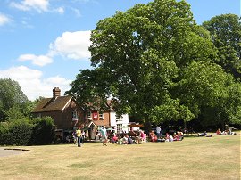
We then continued on through the village, following the road down to St Dunstan's Church, passing the village green before heading besides three small fields to reach a house. Heading across the track the route enters the next field and bears to the right following the field edge up to the top of the field before continuing ahead to briefly join Matthew Lane. Despite having walked here before, anyone looking in detail at the route on Garmin (see link below) will see we went slightly of course here however I did retrace my steps to take the correct route round the field. Leaving Matthew Lane the route continues ahead on a track running between fields which leads to the road at Gover Hill. Crossing the road, the route joins a track on the other side which soon leads to a field. The path heads down and then up over a number of fields before joining a path running diagonally through an orchard, photo 17, which takes the Greensand Way to the road at Roughway Lane. Here we had what was probably the longest stretch of road walking after Yalding, which wasn't that long anyway, as we followed the road to the left as it makes it was round to the Dunks Green Road. Dave had been feeling a little under the weather and at the junction of the roads we stopped for a short break at the Kentish Rifleman Pub, a break which was welcomed by all and which soon left him refreshed enough to finish the rest of the walk. Leaving the pub we headed a short distance down Dunks Green Road before taking a footpath on the right. This soon heads across a field to a small wood before heading across the middle of another field, photo 18, to reach School Lane.
 |
 |
 |
(19) Shipbourne |
(20) The Common, Shipbourne |
(21) Farmland nr Shipbourne |
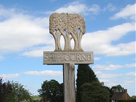
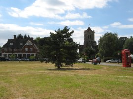
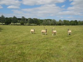
Crossing School Lane the Greensand Way heads along the driveway of Fairlawne Home Farm, heading gently downhill alongside a field with trees to the left before heading the middle of another field to join path that runs between he backs of some large gardens to join Upper Green Road on the outskirts of Shipbourne, photo 19. The path follows the road over the common, photo 20, and crosses the A227 to head round the side of St Giles Church. Leaving the churchyard the route bears to the right, the path following the field edge before crossing a hedge and continuing ahead over grassy field that was being grazed by sheep, photo 21.
 |
 |
 |
(22) View back to Shipbourne |
(23) Greensand Way, Rooks Hill |
(24) One Tree Hill |
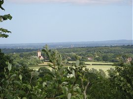
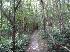
Reaching the end of this field the route heads to the left along the bottom edge of another field before turning to the right to cross the field and heading uphill into a patch of woodland. Leaving the trees the route joins another field edge path that runs alongside Mote Road. At the end of the field the route joins the road for a short distance before turning left onto a driveway by Mote Farm. Heading by some barns the route bears to the right along a farm track which is followed for some distance to an isolated house by Wilmot Hill. Since we had descended to Yalding there had not been much clear indication of the Greensand Ridge but the route is now steadily climbing up and the ridge becomes once again more defined, for a while opening up views over the countryside, photo 22. Just past the house the route joins a field edge footpath that soon leads into woodland, the path running through trees below the top of Shingle Hill. The route briefly leaves the trees before heading uphill along a track and then turning left to join a footpath, photo 23, running through the trees of Rooks Hill, the views now limited to the odd gap in the trees. Just before the path reaches Carter's Hill we left the Greensand Way, joining a path on the right that headed up to our parking spot close to the top of One Tree Hill, photo 24.
The GPS made this walk 16.2 miles long. It had been a very pleasant walk in lovely weather with good company, the first section along the Greensand Ridge towards Yalding being particularly stunning with the combination of fields and orchards and the views across the ridge.
I have uploaded the route of the walk which can be accessed here Greensand Way 3 Route.
If you would like to comment on this walk you can do so here:
![]() Back to:Walk index page
Back to:Walk index page
| ©2012 Bertuchi.co.uk. Please contact me using the email button on the right if you have any questions or comments regarding the site. Any feedback and additional information about places of interest on the walks is always welcomed. All rights reserved. Please contact me if you want to use any of the images or information from the site. ENJOY YOUR WALKING |
|