South Bucks Way Waymarker
Other Links >>> |
|
THE SOUTH BUCKS WAY - PART 1
Wendover to Amersham
|
|
South Bucks Way Waymarker |
I did this walk on Sunday 14th October 2007. I drove up to Amersham and then took the train for the two stops up to Wendover. The car park by the station was free on Sundays and the rail journey cost £4.10 for the twelve minutes of travel. A number of long distance paths pass through or close to Wendover including the Ridgeway, Ickneild Way, Chiltern Way and Aylesbury Ring and a number of walkers got off the train up from Amersham at Wendover station. These are all paths that I would also cross or share some part of my route with, at some time or other during the day.
 |
 |
 |
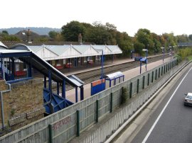
(1) Wendover station |
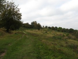
(2) Heading up Bacombe Hill |
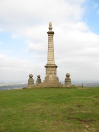
(3) Coombe Hill Monument |
Leaving Wendover Station, photo 1, I took the footbridge back over the railway lines and A 413 before taking a footpath that runs alongside a small cricket ground. The route passed under an electricity pylon and the wires were making a loud crackling sound as I passed by. I then turned left along a track, joining the route of the Aylesbury Ring path for a few yards, down to a road. Here I turned to my right and joined the route of the Ridgeway National Trail. After a short distance I continued following the route of the Ridgeway as it bears left, away from the road, and starts heading along a footpath that runs first up Bacombe Hill, photo 2, and then continues on to reach the summit of Coombe Hill and a height of 260 meters. There was a monument on top of the hil, photo 3, erected in memory of those men from Buckinghamshire who lost their lives during the1899-1902 South Africa War. A plaque on the back of the monument records how in 1938 the monument was almost totally destroyed by lightning and was rebuilt the same year.
 |
 |
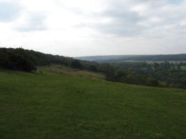 |
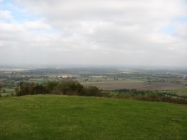
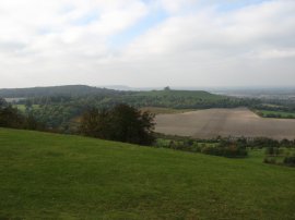
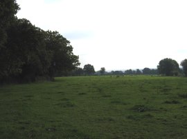
(4) View over Aylesbury |
(5) View along the Ridgeway |
(6) The start of the South Bucks Way |
From the top of the hill there were wide ranging views over the Vale of Aylesbury, photo 4, and along the ridgeway, photo 5, although these were somewhat limited by the rather hazy weather. The monument marks the official start of the South Bucks Way and was 1.4 miles from Wendover Station. The route follows the Ridgeway along the side of the hill, photo 6, before entering into a patch of Beech Wood.
 |
 |
 |
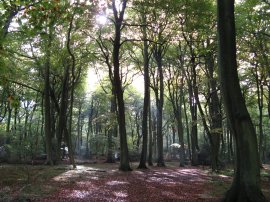
(7) Beech Trees |
(8) Heading towards Hampdenleaf Wood |
(9) South Bucks Way |
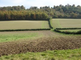
Reaching a road the route turns right for about 100 yards before turning left and continuing to follow the Ridgeway through another patch of Beech woodland by Fugsdon Wood. The path here was lined by tall beech trees whose canopies rose far above the path, photo 7. The route winds its way through the woodland before heading more steeply downhill to reach the edge of the forest where the South Bucks Way leaves the route of the Ridgeway and turns left along a bridleway that heads back uphill through an area of much younger mixed woodland. The route heads through the forest to reach an overgrown tarmac track where the route turns left for a short distance before bearing left along a footpath that continues to run through the trees. The route joins a lane by the Rising Sun pub in the hamlet of Littel Hampden and continues down the lane before linking up with the route of the Chiltern Way and turning left to head back into the woodland down a broad track before taking a footpath the heads off down hill to the right through the trees. The route then continues out between open fields across the bottom of a valley, photo 8, before heading up to pass quite steeply through more trees on the other side of the valley. The path leaves the trees and crosses diagonally to the right over a small grassy field on the hilltop to join a track that runs off to the right. This crosses a road and continues down a driveway before the Chiltern Way turns to the left and the South Bucks Way continues ahead along a bridleway that runs just inside a path of woodland. The route leaves the bridleway and takes a footpath that then runs alongside the edge of the field, photo 9. Halfway through a second field the route rejoins the bridleway and continues ahead along the path towards Great Missenden. Overhead I could hear the occasional call of a Buzzard although I never saw it.
 |
 |
 |
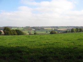
(10) View over the Misbourne Valley |
(12) Approaching Great Missenden |
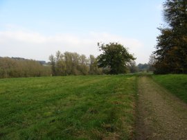
The bridleway runs along a hedge lined track with fields on either side and the hedges and trees rather restricted the views, photo 10, available from the path for much of its length. At a junction in the path I turned the wrong way and headed down to reach the A 413 by Woodlands Park where I realised I had gone the wrong way and had to retrace my steps uphill to re-join the correct path, a diversion that added 0.8 mile to my journey. The junction was signed, I was just not paying sufficient attention again. The South Bucks Way eventually leaves the bridleway to head along a footpath that runs off to the left that runs through more trees, about a quarter of a mile further along the path than where I had turned off in error. Leaving the trees the path heads down over open fields, photo 12, into the Misbourne Valley.
 |
 |
 |
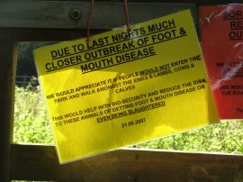
(13) Path closure notice |
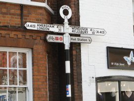
(14) Great Missenden High Street |
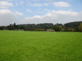
(15) Playing fields, Great Missenden |
The route passes under the railway lines that I had travelled on earlier and heads down to cross the A 413 road by the Black Horse pub, besides a dried up pond. The route then takes a footpath into a field besides the pub The field is also used for balloon flights and when I went through contained a number of tents, most of which where in the process of being dismantled. Each tent had a motorcycle parked outside and as I passed through the field a female biker very kindly offered me a biscuit. This got me thinking about my own motorbike which has been parked up at work for almost a year. Security are starting to hassle me to do something with it although it is far safer there than parked at home and I don't really want to get rid of it at the moment. From the field the route then passes through another field where the rather vague path heads towards a stile in the left hand corner and a small paddock, running parallel with the A 413 . Leaving the paddock the route crosses a road and heads along a tarmac footpath alongside the edge of some playing fields in Great Missenden. The route passes a school, crosses a small village green and heads up Church Lane. Just before the bridge over the A 413 the route descends a flight of steps to take kissing gate into the grounds of Great Missenden Abbey. Here the path was closed due to the recent outbreaks of foot and mouth disease. This was a voluntary request, photo 13, not to use the path rather than an official closure of the path but the gates was tied shut and after stopping to eat lunch on the steps I decided to make a detour round field. Thus I headed back done Church Lane and then turned left along Church Street to reach the High Street, photo 14. An old style signpost showed it 4 1/2 miles to both Wendover one way and Amersham the other. Church Street was lined with a number of very attractive cottages and well worth walking down. Turning left, the High Street runs into the London Road and where I rejoined the route of the South Bucks Way as it exited the grounds of Great Missenden Abbey Parklands. I then headed across the road and took a path that runs round two sides of a playing field, photo 15, where a couple of junior football matches were taking place, complete with over zealous parents coaching from the touchlines.
 |
 |
 |
(16) Fenced path through Little Kingshilll |
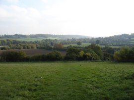
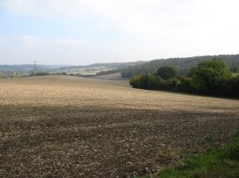
(17) Fields nr Little Missenden |
(18) Little Missenden |
The path heads up to cross under the railway lines again and then turns left to take a path running along the edge of a field that heads gently uphill towards the village of Little Kingshill. Reaching the village the South Bucks Way takes a fenced lined path, photo 16, for quite some distance between the houses before turning right and continuing more gently uphill along New Road. At the end of New Road the route continues ahead into Hare Lane where the route of the South Bucks Way continues straight ahead. Reaching the Full Moon pub the route takes a footpath that heads off to the left by Grange Cottages. This runs down besides a house and across a recreation area. Reaching a road the route turns left along Windsor Lane. This road is followed past houses for some distance, the only significant stretch of roadside walking during this part of the South Bucks Way. Reaching a bend in the road the route turns right along a bridleway that heads between trees for a short distance before reaching the edge of a large field with extensive views down the valley towards Little Missenden, photo 17. Here I once again went slightly off course as the footpath more or less continues straight ahead, heading for the electricity pylon in the distance whilst I started following the track around the field edge. Realising my mistake I then had to track back across the field to reach the correct route although this could not really been seen on the ground. The field had only recently been ploughed and looking closely I could only make out one other set of footprints in the soft chalky soil once I was back on the right route. The route heads across the corner of another field under the electricity lines and then runs along the field edge down to a track. Reaching the track the route turns right along a very overgrown stretch of path, it would have been easier to continue round the side of the field to the gateway which is probably what most people have done and explains why the track was so overgrown. The route then turns left to follow a field edge down to a road, Penfold Lane, where the route continues ahead for a short distance down to the outskirts of Little Missenden, photo 18. It was very pleasant walking along the besides the fields, peaceful and quiet, with only the sound of birdsong to disturb the silence with gently hill rising to my right, their summits topped with small patches of woodland. It was a very pleasant walking weather too with almost no breeze and plenty of warm hazy sunshine and my fleece remained in my rucksack all day.
 |
 |
 |
(19) Heading towards Amersham |
(20) Lake nr Shardeloes |
(21) Amersham High Street |
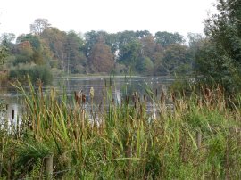
Reaching the junction with Beamond End Lane the route continues straight ahead, once again running along side a field edge. The route then cuts across the corner of this field and heads down to Abbot Road in Little Missenden where the route turns right. The South Bucks Way then heads along the road, past a pub, before taking a broad and well surfaced track off to the right. As with all the pubs I had passed during the walk there was a large gaggle of people outside smoking and I wondered what they were going to do when the weather becomes less pleasant. It was also interesting hearing the odd snippets of conversation as I made my way past "I was in India in '71, of course you can't breathe the air now in Dehli" was one such comment I overheard when passing by. Rugby shirts were also very much in evidence after Englands victory over the French in the rugby world cup the previous evening. It made me chuckle reading the back pages of the papers calling the England players heroes when just two weeks ago the very same papers were calling the team the worst England Team ever and saying only a foreign coach could turn the team around. The route continues ahead along a more grassy track when the surfaced track turns to the left, running parallel with the River Misbourne and the rather noisy A 413, photo 19. The route then passes an ornamental lake, photo 20, on the left. The lake is in the grounds of Shardeloes, an old country house, and was formed by damming the River Misbourne. Continuing on the South Bucks Way then passes round the edge of the cricket ground of Amersham Cricket Club. Reaching a road the route turns left and passes through some imposing metal gates and continues ahead along a tarmac footpath that takes both the route and the River Misbourne under the A 413. The route the follows the A road for a short distance before taking a footpath that bears off to the left down to join Amersham High Street, photo 21, which is followed into Amersham Old Town.
 |
 |
 |
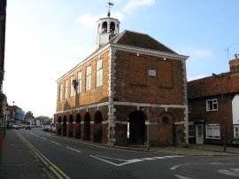
(22) Amersham Market Hall |
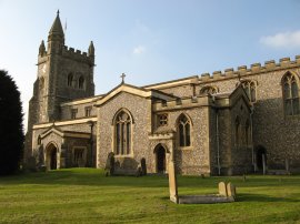
(23) St. Mary's Church, Amersham |
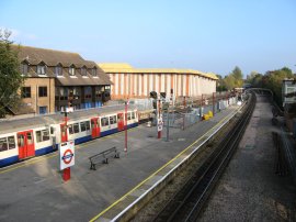
(24) Amersham Station |
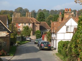
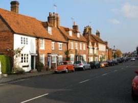
The High Street was lined by a number of very attractive buildings and houses which I passed as I made my through the Amersham Old Town. Reaching the Market Square the route passes the 17th century Market Hall, photo 22, given to the town by the Drake family who werre also the owners of Shardeloes at the time. From the market square I headed into the Broadway where I finished my walk along the South Bucks Way for the day.
I had walked 12.9 miles when I turned off the South Bucks Way which made 10.7 miles walked along the route of the path. From the Broadway I then headed steeply uphill past the church, photo 23, through a small patch of woodland and on to Amersham station, photo 24 from where it was just a short walk back to where I parked my car.
The total distance I had walked was 13.7 miles. I know I seem to say this for most walks but this had been a particularly pleasant days walking through gently hilly countryside with a considerable amount of woodland, the leaves on the trees starting to show a variety of reds and yellows. There was little road walking and the in general the paths were easy to follow although it was fortunate that the weather was nice and dry otherwise some of the ploughed fields would have been a bit unpleasant to cross. The route was generally well way marked although there were a number of places where the signs were missing and I would have found it difficult to follow the route without a map. I hope to walk the second part of the path down to Denham lock in a couple of weeks time.
![]() Back to:Walk index page
Back to:Walk index page
| ©2012 Bertuchi.co.uk. Please contact me using the email button on the right if you have any questions or comments regarding the site. Any feedback and additional information about places of interest on the walks is always welcomed. All rights reserved. Please contact me if you want to use any of the images or information from the site. ENJOY YOUR WALKING |
|