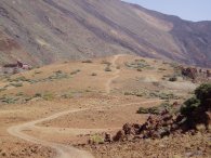
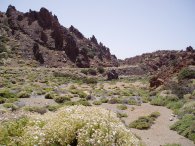
(1) Path to Montaña de Majua
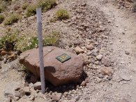
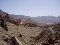
(2) Sendero 19
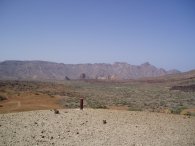
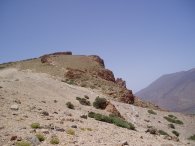
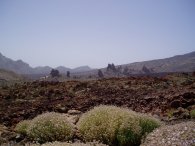
(3) View across Las Cañadas
LAS CAÑADAS
I did this walk on 26th July 2006. Las Cañadas is a large volcanic crater ringed by a line of mountains on the island of Tenerife. The volcanic actvity required to form a crater that is many kilometers across must have been truly awesome. The floor of the crater itself is over 2000 mts high and the scenery in the area absolutely stunning, my camera is getting a bit dated and the photos don't really do the area justice or give an idea of the scale of the area. Driving up from Callao Salvaje on the coast the views just got better and better the higher the road climbed and the entrance into the crater along the TF21 was breathtaking. As well as being a simply amazing place to go for a walk I was also using this day to experience walking at a far higher altitude and temperatures than I am used to, ready for my ascent of Mount Tiede.
|
|
|
|
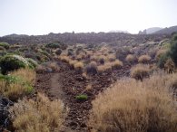
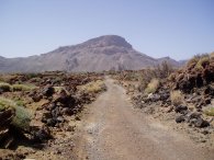
(1) Path to Montaña de Majua |
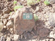
(2) Sendero 19 |
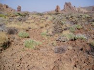
(3) View across Las Cañadas |
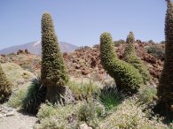
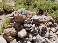
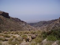
I parked at the small car park by the Parador Nacional de las Roques and started heading across the floor of the crater in the direction of Montaña de Majua, which is close to the base of the cable car station up Teide. The path, photo 1, was quite uneven at first at first although it became better later. This route is walk number 19 in the National Park and was marked by the occasional small green plaque, photo 2. The path was surrounded by dramatic views on all sides, photo 3, as well as being home to hundreds of grasshoppers forever jumping left and right as I approached.
 |
 |
 |
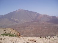
(4) View towards Teide |
(5) Approaching Montaña de Majua |
(6) The summit of Montaña de Majua |
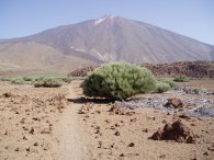
The path is generally level as it makes its way towards the Montaña de Majua with Teide looming ever larger in the background, photo 4. The mountain itself is only a very small peak which barely rises above the general level of the crater floor. The path up to the "summit" can be seen in the middle of photo 5. Photo 6 was taken from the summit looking back across from where I had walked towards Las Roques, some two and a quarter miles away.
 |
 |
 |
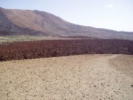
(7) Montaña Blanca |
(8) Las Cañadas crater, Teide |
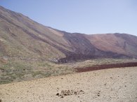
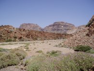
(9) Montaña de Guajara |
Photo 7 was taken from the summit of Montaña de Majua looking towards Montaña Blanca where an old lava flow can clearly be seen down the side of the mountain. Photo 8 shows another brown mass of lava in the crater floor. Descending from the Montaña de Majua I then began heading across the crater towards Montaña de Guajara, photo 9. This is walk number 16 and is known as the Sendero Sanatorio. The following website Parque Nacional Teide gives more details of all the walks in the Teide National Park. The path runs along an old jeep track and has a relatively good surface to walk on as it makes its way through the lava fields of the crater floor and I was able to make good progress towards the base of Guajara.
 |
 |
 |
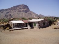
(10) Sanatorio del Teide |
(11) Las Cañadas crater, Teide |
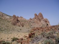
(12) Volcanic Spires, Guajara |
The path makes its way past the buildings of the Sanatorio, photo 10, which now seem to be used by the national Park staff and continues on to join sendero 4, close to the base of Montaña Guajara. Mount Teide can be seen in the background of photo 11 although I am unsure what the plant is in the centre of the photo although after further research I think it may be Pterocephalus lasiospermus. Photo 12 shows a rocky outcrop on the side of Montaña de Guajara although it is impossible to judge just how tall they are from the photo.
 |
 |
 |
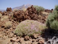
(13) Teide Bugloss |
(14) Sendero 5 |
(15) Degollada de Guajara |
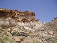
Photo 13 shows a coupe of Teide Bugloss plants, These can reach about 10 feet in height althought the examples in the photo were nearer six feet tall. Turning left onto sendero 4, which is another jeep track, the path heads downhill for a short distance before the start of sendero 5 is reached on the right, marked by a small cairn and a green plaque with the number 5, photo 14. This is a short stretch of path, about a mile in length that runs up the side of Montaña Guajara to the Degollada de Guajara, photo 15. The Degollada de Guajara is a col on the rim of the crater with Montaña Pasajirom rising to the left and Guajara to the right. Ahead are views over the South of the island down the Barranco del Río toward the Reina Sofía Airport.
 |
 |
 |
(16) Degollada de Guajara |
(17) Sendero 15 |
(18) Approaching the summit of Guajara |
From the Degollada de Guajara I turned right onto sendero 15, the Sendero del Alto de Guajara. This leaves the col and runs along the South side of the mountain for a short distance below the pumice cliffs in photo 16, (the Degollada can be seen in the right of the photo). A little further on a metal pole and sendero 15 plaque, photo 17, mark the start of the second stage of the ascent of Guajara. By this stage I was beginning to feel quite tired and the uphill path, altitude and heat meant I was walking at a fairly slow pace. Not wanting to completly exhaust myself and to keep fit for Teide I decided to walk up the path for half an hour or so and turn round at that point. Photo 18 was taken not long before I turned round. The summit of Guajara can be seen in the distance although it is very difficult to get a feel of the scale of the area from the photo.
 |
 |
 |
(19) Mount Teide |
(20) Las Cañadas crater, Teide |
(21) Path around the foot of Guajara |
Photo 19 was taken from the edge of the mountain looking across where I had walked earlier over the Las Cañadas crater towards Teide. From here I then retraced my steps back to the crater floor, photo 20. It was considerably easier descending although care had to be taken not to slip on the loose areas of rock. It was also suprising how much heat was being reflected back off the ground, particularly from the lighter stretches of pumice. I then turned left back onto sendero 4, the Sendero de Siete Cañadas, and made my way back round the side of Guajara, photo 21, along the crater floor towards the Parador.
 |
 |
 |
(22) Las Cañadas crater, Teide |
(23) View towards Los Roques |
(24) Piedras Amarillas |
In photo 22 the route of the sendero 4 can be seen winding round the edge of the crater with the Peidras Amarillas in the middle distance and the western edge of the Cañadas crater on the horizon. Los Roques can be seen in the middle distance of photo 23. Finally sendero 4 makes its way past the Piedras Amarillas, photo 24, and back towards the Parador.
The GPS made this walk 10.9 miles long and it was one of the most enjoyable walks I can remember doing.
I carried three litres of liquid which was just about the right amount for the walk. One of the bottles I had frozen before I left and I also put a freezer pack in my aluminium lunch box. This helped keep my rucksack and drinks cool throught the day despite the temperature being around 30c. The freezer pack was a bit heavy though and I didn't use it up Teide. Being mid summer the whole area was very quiet and I saw no one all day until I had descended from Guajara and was back on sendero 4 and heading for the Parador when I was passed by three separate couples in the last mile or so. I guess in cooler times the area would be far more popular with walkers but in mid July I had complete solitude.
![]() Back to:Walking index page
Back to:Walking index page
| ©2008 Bertuchi.co.uk. Please contact me if you have any questions or comments regarding the site. Additional information about places of interest on the walks is always welcomed. All rights reserved. Please contact me if you want to use any of the images or information from the site. Thank you. |
|